|
|
|||||||||||||
| HOME | :: | WHAT'S NEW | :: | PROJECTS | :: | SAILING | :: | MAINTENANCE | :: | RESOURCES | |||
| SAILING LOGS :: EQUIPMENT AND STORAGE :: MISCELLANY | |||||||||||||
|
Day 1--Thursday, August 30 As usual, I began early in the day by bringing the boat into the dock from the mooring for loading, ice, and water. I had previously filled the fuel tank. I loaded 30 pounds of ice block and 10 pounds of cubes (2 bags). This left a little more room for food--I had overloaded the icebox with ice for our cruise to Pemaquid earlier in the month, and fitting in the food for 4 days was tough at that point. This time, I used one less block, which gave plenty of extra room. I also loaded all the rest of the junk we seem to need when we cruise. I must be getting better, because everything disappeared nicely into lockers without a fuss. I stored an extra 5-gallon jerry can of diesel at the port shrouds, thoroughly lashed in place. It was a perfect late summer day--temperatures in the 70's with bright sun and light wind, with one of those dark blue skies overhead. Beautiful. I was happy to be loading the boat and cleaning while poor Heidi was stuck at work--that's a trade I'll take any day! When the boat was loaded and cleaned, I launched the dinghy and returned the boat to the mooring. Late in the afternoon, we returned to the boat. Because of the earlier sunsets (about 7:15), we didn't really have time to get anywhere before dark, so we chose instead to relax at the mooring until the morning. Unwinding began immediately. The night was still, but clouds came in from nowhere to cover the entire sky by 10 PM. Day 2--Friday, August 31 The morning dawned humid and hazy, with 7/8 cloud cover. By 8:00, I was ready to go, so I woke Heidi and raised the main with one reef. The forecast was for 15-25 knots of wind, so I wanted to be prepared. Already, the wind was brisker than normal for this time of day.
The trip down to Quahog is a short one--about
three hours--and not too difficult or open, but it does require heading in
through one of several reef-strewn passages to get to the inner bay, which was
our destination. These passages are certainly open enough, but most
contain several unmarked ledges that may or may not be breaking, depending on
the conditions. One of the easier--and, from the west, it happens to be
the shortest--passages involves heading in along the eastern shore of Bailey
Island, and, further in, Orr's Island. This is the route we took
today. It is exposed to the south, the direction the ocean swells come
from. On this day, the wind ended up exactly, directly, perfectly behind
us as we proceeded down the channel. The main, which had up until this
point been a steadying influence and had added substantially to our speed,
suddenly became a lethal weapon as it threatened to jibe repeatedly. To
prevent this, I sheeted it in tightly--and none to soon, as shortly thereafter
the wind began oscillating side to side over the transom, causing the sail to
jibe repeatedly as we headed through the 3-mile pass. With the sail
sheeted on centerline, this was not dangerous--but we missed its push, and the
steadying effect it had had. The swells coming in were hardly dangerous or
even spectacular, but were large enough to make steering dead downwind before
them less than enjoyable. Soon, though, we rounded the mark at Middle
Ground, and were able to change
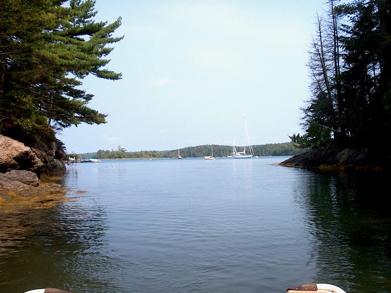
We motored around the coves looking for the perfect spot to anchor. There are a number of moorings in the southern part of the cove, which is too bad because it's one of the best places to anchor. Fortunately, there's still plenty of room to anchor. Although the wind was southerly when we arrived, it was predicted to shift to the northwest later in the night as a cold front approached. Therefore, I wanted to pick a spot where we would be safe and comfortable through both wind directions. I chose a spot outside of the moorings, and we dropped the anchor--a 35# CQR stored on a bow roller. It grabbed immediately, and set perfectly under full reverse. We had arrived! I don't have our rode marked for length yet, so I don't know how much scope I put out. I judged it by the angle between the rode and the water. Nearby was a beautiful wooden 50-some-foot yawl, Windalier. Classic, and beautifully maintained, with a sheerline and overhangs to die for. I coveted it.
Glissando anchored at Snow Island on Friday.
As the evening wore on, fog rolled in, obscuring most of the scenery. However, there was a nearly full moon--very bright--that continued to provide a luminescent lighting quality to the scene--very interesting. I awoke several times during the night to check the position of the boat and make sure the anchor was holding. I had previously noted several landmarks, including nearby moorings, the shoreline, and several lights on the shore. These remained visible throughout the night, despite the fog. At one point, I woke and looked out my porthole, only to see what I was sure was one of the nearby moorings--a white ball--in a position where it shouldn't--and couldn't--be. Concerned, I peeked out the overhead hatch, only to realize, through sleep-fogged eyes, that what I was seeing was a loom surrounding one of the distant shoreside lights I was using as a position indicator, right where it was supposed to be. It's funny how your eyes can play tricks sometimes. In the wee h ours, the promised cold front finally passed through, with a few weak thunderstorms and heavy rain showers. At least one of the storms was extremely close, but there was no wind to speak of. The bilge pump cycled on and off repeatedly throughout the night as rainwater entered the bilge. This was annoying. The water comes into the bilge through a couple of avenues. I have one of the cockpit scupper seacocks closed, since I had trouble getting the clamp to hold the hose on properly. Therefore, when it rains hard, water builds up in the cockpit more than it normally would, and then flows through the not-watertight (despite the advertising) deck hatch I installed there. This is on my project list before next season. Later, the wind shifted to the northwest, light-- a sure sign of clearing weather.
|
|||||||||||||
|
|||||||||||||
 We dropped the mooring and powersailed for Quahog Bay and Snow
Island, our destination for the day. We could have sailed, and maybe we
should have, but with the forecast that NOAA was giving, we thought it might
just be nice to get there--we're not big fans of 25-knot winds if we can easily
avoid them. We took the usual eastbound route through Chandler Cove, out
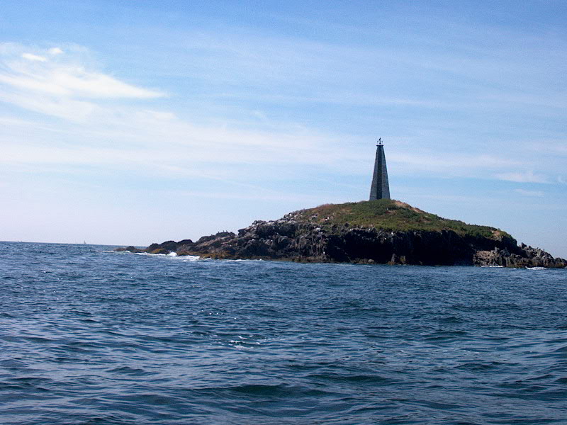
Broad Sound, and past Little Mark Island with its unique monument
landmark. The story is that not only was this constructed as a memorial to
the numerous shipwrecks and sailors lost in the nearby waters--they are strewn
with reefs, many of which are only barely awash at low tide--but that there is
also a small chamber in the bottom of the monument to provide a safe haven for
any shipwrecked sailors who were lucky enough to make it to the island.
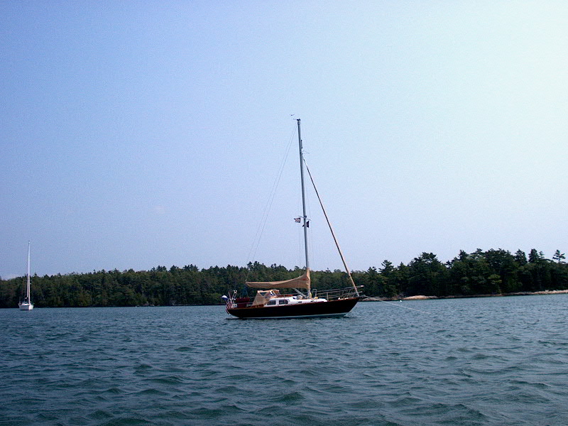
I'm not a historian (is it "an" historian?), so if this is not
accurate please forgive me--and let me know the real story! Note that I
took this photo on our return trip, a much nicer day than our first day--so if
the weather looks more benign than I've been describing, it is! Call it a
file photo, if you will. (I didn't take any pictures on Friday.)
We dropped the mooring and powersailed for Quahog Bay and Snow
Island, our destination for the day. We could have sailed, and maybe we
should have, but with the forecast that NOAA was giving, we thought it might
just be nice to get there--we're not big fans of 25-knot winds if we can easily
avoid them. We took the usual eastbound route through Chandler Cove, out
Broad Sound, and past Little Mark Island with its unique monument
landmark. The story is that not only was this constructed as a memorial to
the numerous shipwrecks and sailors lost in the nearby waters--they are strewn
with reefs, many of which are only barely awash at low tide--but that there is
also a small chamber in the bottom of the monument to provide a safe haven for
any shipwrecked sailors who were lucky enough to make it to the island.
I'm not a historian (is it "an" historian?), so if this is not
accurate please forgive me--and let me know the real story! Note that I
took this photo on our return trip, a much nicer day than our first day--so if
the weather looks more benign than I've been describing, it is! Call it a
file photo, if you will. (I didn't take any pictures on Friday.)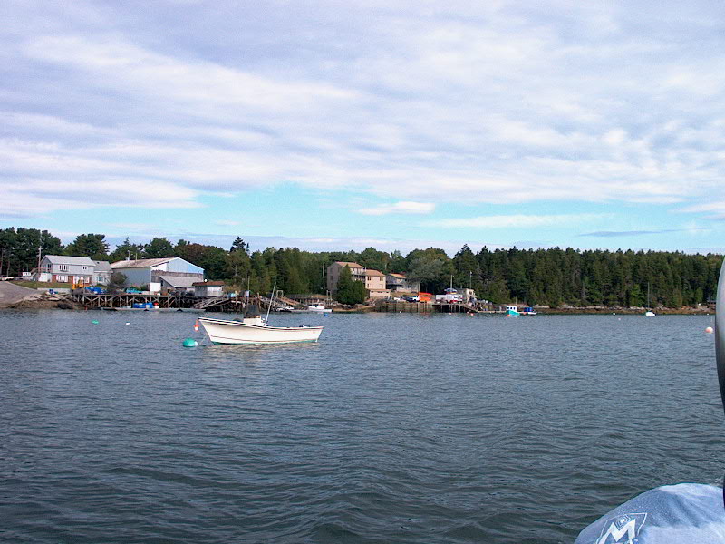 course
enough to the east to make the motion more comfortable. Then, it was as
easy passage the next mile or two until we rounded Long Point Island and entered
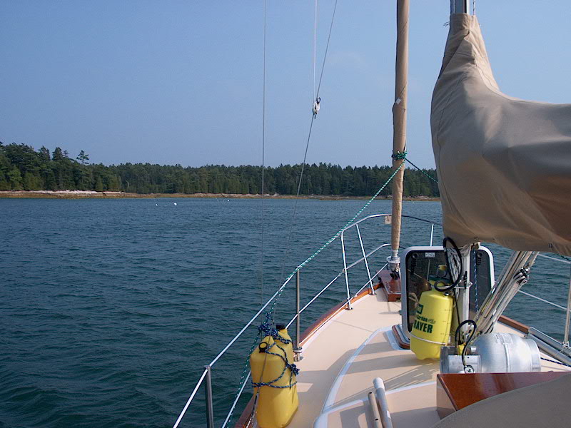
the bay. Heading into Quahog bay is a beautiful experience--much like
heading up a narrow river. The shoreline is extremely bold, and the water
deep. The pass between Pole Island and the larger, Sebascodegan island to
the west is narrow and beautiful, and quintessentially Maine as you pass by Card
Cove and then the lobster co-op with several lobster boats moored out
front. As you head in, the ocean quickly recedes in the distance, and a certain
calm comes over the wind, waves--and cruisers! I remember the entrance
being clogged with lobster pots, making navigation tough--but there were fewer
than I remember, and it was no trouble to steer around them. North of Pole
Island, the bay opens up into a beautiful expanse, unspoiled--although only
about 5 miles away from Brunswick. You'd never know you were anywhere
close to civilization, though. Oh sure, there are houses dotting the
shores, but they hardly spoil the feeling of isolation.
course
enough to the east to make the motion more comfortable. Then, it was as
easy passage the next mile or two until we rounded Long Point Island and entered
the bay. Heading into Quahog bay is a beautiful experience--much like
heading up a narrow river. The shoreline is extremely bold, and the water
deep. The pass between Pole Island and the larger, Sebascodegan island to
the west is narrow and beautiful, and quintessentially Maine as you pass by Card
Cove and then the lobster co-op with several lobster boats moored out
front. As you head in, the ocean quickly recedes in the distance, and a certain
calm comes over the wind, waves--and cruisers! I remember the entrance
being clogged with lobster pots, making navigation tough--but there were fewer
than I remember, and it was no trouble to steer around them. North of Pole
Island, the bay opens up into a beautiful expanse, unspoiled--although only
about 5 miles away from Brunswick. You'd never know you were anywhere
close to civilization, though. Oh sure, there are houses dotting the
shores, but they hardly spoil the feeling of isolation.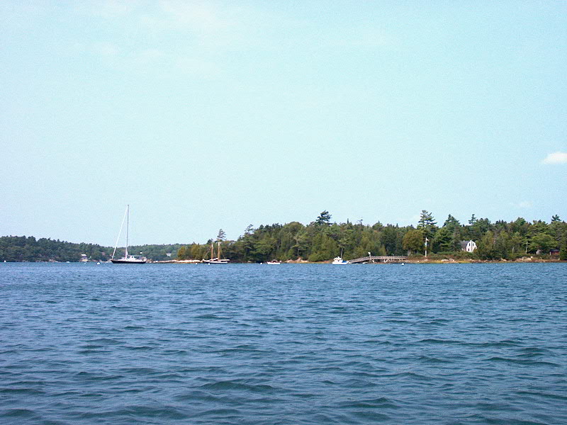 North
of the island, we took down the mainsail, and then motored over to the east to
the cozy coves east of Snow Island--the secluded and envy-producing home of
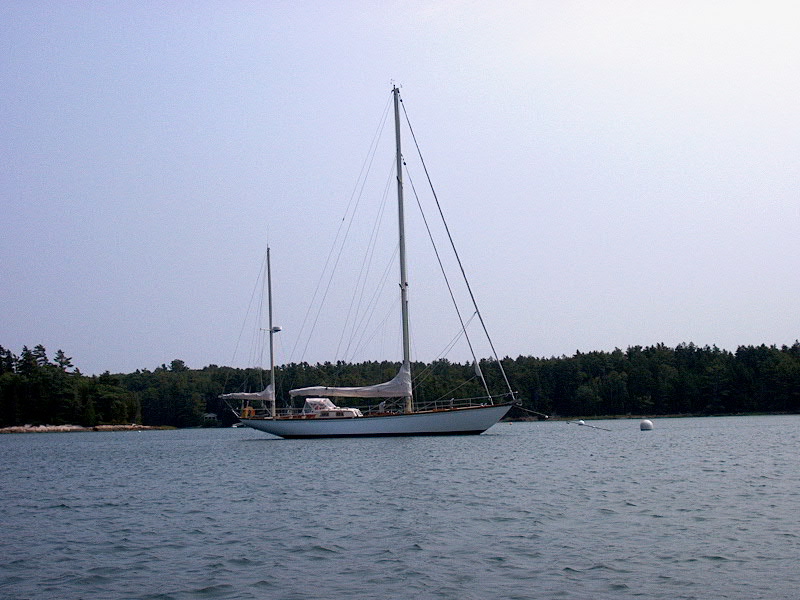
noted singlehander Dodge Morgan. Surprisingly, and happily, the house he
occupies on this small, wild island is small and understated, and fits in well
with its surroundings. His beautiful Little Harbor 53 Wings of Time,
and the quaint schooner Eagle are moored nearby.
North
of the island, we took down the mainsail, and then motored over to the east to
the cozy coves east of Snow Island--the secluded and envy-producing home of
noted singlehander Dodge Morgan. Surprisingly, and happily, the house he
occupies on this small, wild island is small and understated, and fits in well
with its surroundings. His beautiful Little Harbor 53 Wings of Time,
and the quaint schooner Eagle are moored nearby.